While the strongest of Monday’s severe storms that hit the Ozarks was not in the Lakes Region, the intensity of the storms were higher than on Sunday.
The National Weather Service issued several Severe Thunderstorm Warnings for storms that tracked to the north of Branson, that came with some strong winds. A report to the weather service from an Amateur Radio Operator in Forsyth indicated that a large tree branch split off of a trunk due to the strong winds. Storms intensified as they moved into south central Missouri and north central Arkansas. In Missouri, one inch hail was reported in Ozark County with well over two-inch hail reported in areas of Douglas County. The storms got stronger from their causing several Tornado Warnings to be issued.
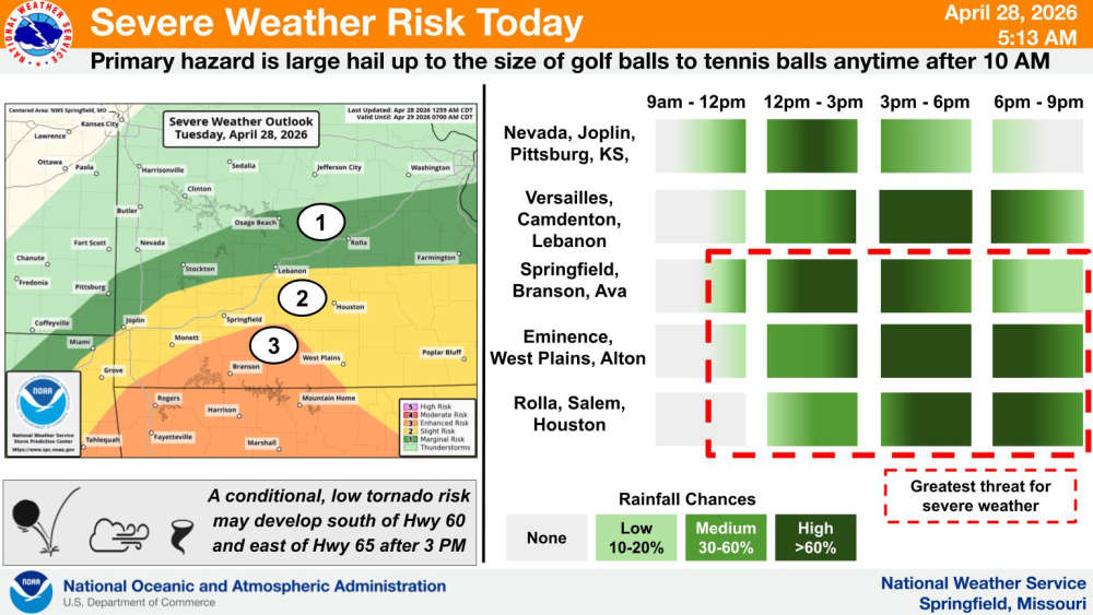
Today is the final day of severe weather according to forecasters, but the Lakes Region has been elevated to an Enhanced Risk of Severe Storms. Hail is the primary threat, but forecasters say a Tornado is a possibility later this afternoon. Storms are expected to develop mid-morning with another round moving through later this afternoon.
After the front moves through tonight, a cooler air pattern will move into place with high temperatures in the 60s and low temperatures in the 40s.
 Duck Boat Pump Fails in Water, Towed Back to Shore
 CDC and FDA Investigate Listeria Outbreak Linked to Recalled Soft Cheese
 UA Northark Hosts “AI in the Classroom Summer Institute” to Empower Educators and Students
 Stone County Officers Assist in Christian County Water Rescue
 Heavy Rain Leads to Swift Water Rescues in Springfield, Wheaton


